Damus

Recent Notes

Organic Maps · 11w
nostr:nprofile1qy2hwumn8ghj7un9d3shjtnyd968gmewwp6kyqpqend6rkuzgpxma5aa78vze7n8pj0efl2d53smlj6lme8q6kvvmtmqjyjjx8 Any good example screenshots with altitude heatmaps from other apps/services?
Alvenster profile picture
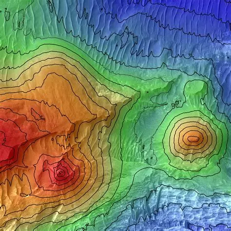
@nprofile1q... No such feature from other apps/services that I am aware of unfortunately. However it could look something like this picture. I'm aware it might not be useful to everyone though but I think it would provide extra readability in special cases ?

1
Organic Maps · 11w
nostr:nprofile1qy2hwumn8ghj7un9d3shjtnyd968gmewwp6kyqpqend6rkuzgpxma5aa78vze7n8pj0efl2d53smlj6lme8q6kvvmtmqjyjjx8 the lack of apps using it is a good sign that it is not useable.
Organic Maps · 12w
Beta testing hill shading and improved isolines (now with feet/meters support). What is your use case for this feature? https://cdn.fosstodon.org/media_attachments/files/117/026/684/976/520/290/origi...
Alvenster profile picture
@nprofile1q... Looks amazing ! Like the idea for hiking and biking. My only concern is that shading the hills is very eye-candy but it might be hard to read ? Why not complement the feature with an altitude as heatmap view ? Could allow users to view the altitude on the map at a glance if 3D shading gets hard to read (for example in situations of slight incline). Also might be a bit better for accessibility ?
1
Organic Maps · 11w
nostr:nprofile1qy2hwumn8ghj7un9d3shjtnyd968gmewwp6kyqpqend6rkuzgpxma5aa78vze7n8pj0efl2d53smlj6lme8q6kvvmtmqjyjjx8 Any good example screenshots with altitude heatmaps from other apps/services?